
News Summary
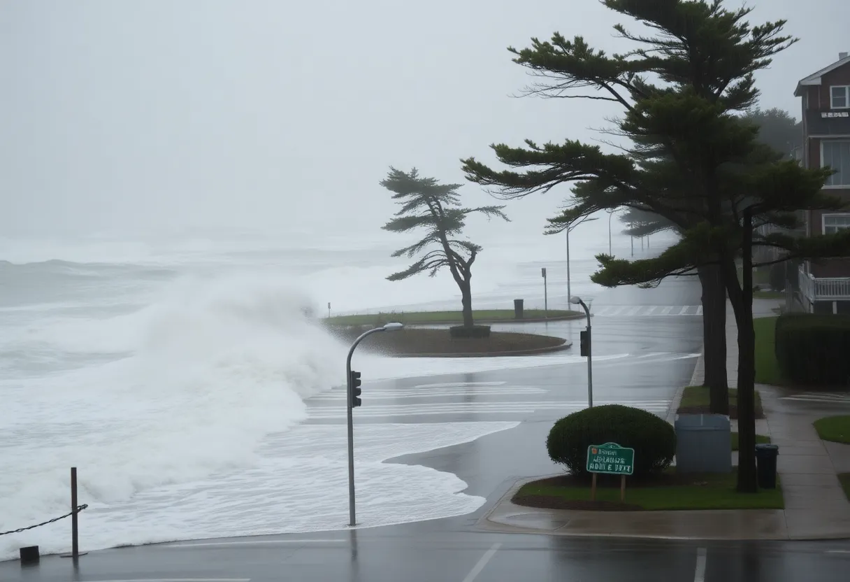
Providence, Rhode Island is preparing for a significant fall nor’easter that could lead to widespread power outages and flooding. The National Weather Service has issued a coastal flood advisory effective October 13. The storm, developing off the coast of Georgia, is expected to bring heavy rain, strong winds, and coastal flooding, especially in low-lying areas. Motorists are urged to take precautions while traveling. Rain and possible thunderstorms will persist throughout the day, with relief expected later in the week as conditions improve.
Providence, Rhode Island is bracing for a major fall nor’easter that is expected to cause widespread power outages and flooding across the region. The National Weather Service (NWS) has issued a coastal flood advisory that will be effective on Monday, October 13, affecting various coastal areas with significant rainfall and strong winds anticipated throughout the holiday.
The most intense impacts of the storm are expected on Columbus Day, which coincides with Indigenous Peoples’ Day, creating hazardous weather conditions without any dry moments. The NWS has warned that Rhode Island will experience strong northeast winds, continuous rain, minor coastal flooding, and beach erosion due to the storm’s effects.
The nor’easter developed off the coast of Georgia late last week, gaining strength as it progressed up the East Coast. The coastal flood advisory is set to be in effect from noon to 4 p.m. on October 13. In particular, low-lying areas of Newport and Washington counties, as well as Block Island, may see flooding of up to half a foot, leading to concerns about localized street flooding.
As motorists prepare for travel, they are advised to allow extra time due to potential road closures resulting from flooding. The NWS cautions against driving around barricades or through water of uncertain depth, emphasizing safety during the storm.
Rain will persist throughout the day on October 13, especially in Providence. Thunderstorms are also possible after 2 p.m., with wind speeds projected to be between 18 and 20 mph, featuring gusts that could reach as high as 34 mph. Showers are likely to continue into Tuesday, October 14, with patchy fog expected in the morning. Winds are expected to decrease slightly on Tuesday, averaging around 14 mph with gusts of up to 24 mph.
Longer-term forecasts indicate that the wet conditions will continue into Tuesday night, but a gradual decrease in precipitation is expected by Wednesday, October 15, transitioning to mostly sunny skies. The weather is expected to dry out on Thursday, October 16, and Friday, October 17, providing much-needed relief from the persistent rain.
The impacts of the storm may lead to downed trees, localized street flooding, and isolated power outages throughout the state. The East Greenwich Emergency Management Agency has issued warnings for severe storms beginning around 1 p.m. on October 12, intensifying the urgency for residents to be prepared.
In East Greenwich, rainfall totals are expected to range between 3 to 4 inches from the beginning of the storm until the peak on Monday. Wind gusts in this area are projected to reach between 35 to 45 mph, further increasing the risk of hazards. Minor coastal flooding is anticipated in low-lying areas, particularly along Water Street.
As of the morning of October 13, utility customers in Rhode Island faced power outages, with approximately 700 reported to be without power. Across the region, an estimated 17,000 utility customers in Massachusetts, Rhode Island, and Connecticut are experiencing outages due to the storm. Reports indicate wind gusts exceeding 65 mph were recorded in some areas, including Block Island and Cape Cod.
Rhode Island has experienced over 2 inches of rain since the storm began, with additional rainfall expected throughout the day. Residents are urged to stay informed and take necessary precautions as the storm approaches, adhering to safety guidance from local authorities and weather service announcements.
Deeper Dive: News & Info About This Topic
HERE Resources
Nor’easter Projected to Impact Rhode Island This Weekend
Cumberland Approves Expansion of Rhode Island Energy Training Facility
Boston Braces for Coastal Storm Impacting New England
Brush Fires Disrupt Traffic in East Providence and Beyond
Severe Nor’easter to Hit Rhode Island This Weekend
Cumberland Planning Board Approves Energy Training Facility Expansion
Brad Valois Wins Rhode Island Mid-Amateur Title
Erin Jones Achieves Career-high Kills in Volleyball Match
One Neighborhood Builders Secures Funding for Center City Apartments
Massachusetts Teachers Face Leave Over Social Media Comments
Additional Resources
- Providence Journal: RI Power Outage Map
- Wikipedia: Nor’easter
- East Greenwich News: Nor’easter Bears Down
- Google Search: Noreaster Rhode Island
- Turn to 10: Weather Alert for Nor’easter
- Encyclopedia Britannica: Weather
- Boston Globe: Nor’easter Weather Forecast
- Google News: Noreaster 2025
- Patch: Dangerous Wind and Rain in RI
- ABC6: Autumnfest Closes Early Due to Nor’easter

Author: STAFF HERE PROVIDENCE WRITER
The PROVIDENCE STAFF WRITER represents the experienced team at HEREProvidence.com, your go-to source for actionable local news and information in Providence, Providence County, and beyond. Specializing in "news you can use," we cover essential topics like product reviews for personal and business needs, local business directories, politics, real estate trends, neighborhood insights, and state news affecting the area—with deep expertise drawn from years of dedicated reporting and strong community input, including local press releases and business updates. We deliver top reporting on high-value events such as WaterFire, Rhode Island International Film Festival, and Rhode Island Comic Con. Our coverage extends to key organizations like the Greater Providence Chamber of Commerce and Providence Warwick Convention & Visitors Bureau, plus leading businesses in finance and manufacturing that power the local economy such as Citizens Financial Group and Textron. As part of the broader HERE network, we provide comprehensive, credible insights into Rhode Island's dynamic landscape.